Photo: kallerna · CC BY-SA 4.0

A lovely day trip from Tirano
Distance and time from Tirano are calculated to the nearest point reachable by car to the place of interest: the rest of the route is on foot. Always check the route and distances carefully before setting out, also for possible seasonal or temporary closures of roads and passes.
At 2,758 metres, three roads, 88 hairpins, the legend of Coppi and a glacier where you ski even in summer: Italy's highest pass is a mountain to live, not just to cross.
- Type
- Mountain passes and springs
- Municipality
- Bormio
- From Tirano
- Visit time
- Opening
- May 25 - November 5Normally from late May to October or November; snow and avalanches can block it even in summer.Indicative dates, not official: check before you go.
- Activities
- Road cyclingAlpine skiing
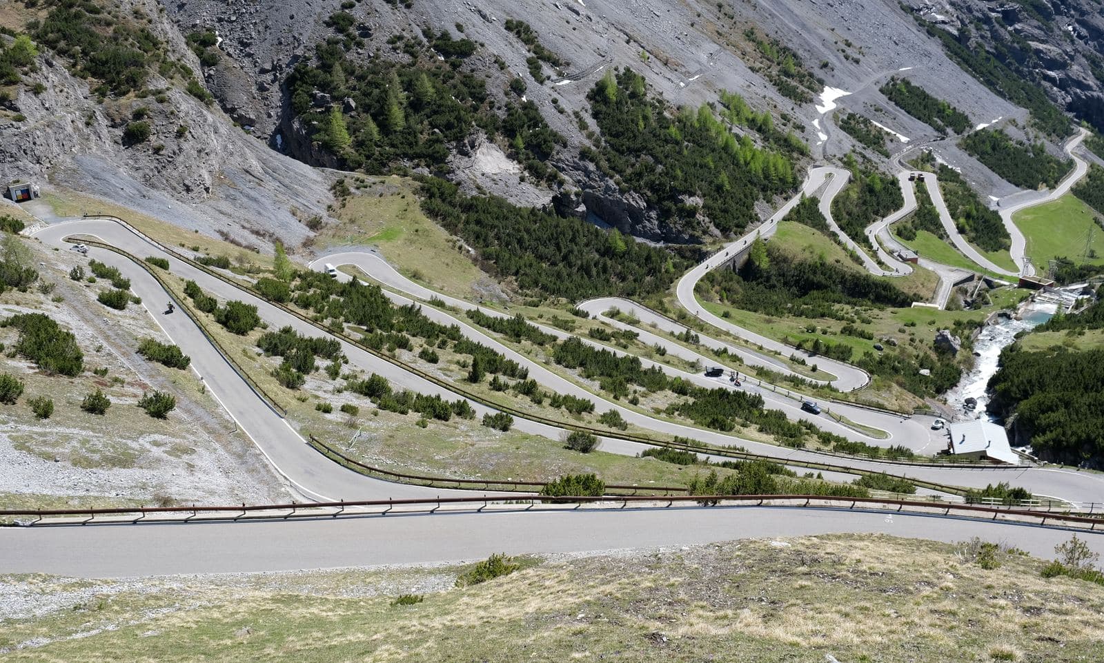
There are places you cross and places you remember forever. The Stelvio Pass belongs to the second kind. At 2,758 metres it is the highest paved pass in Italy, in the heart of the Stelvio National Park, and its profile, that ribbon of hairpins zig-zagging up the rock, has become one of the most recognisable images of the Alps.
You reach it by three roads, each with its own character. From Bormio, on the Lombard side, you climb about 22 kilometres with 1,533 metres of ascent. From Prato allo Stelvio, in South Tyrol, the way is the longest and hardest: nearly 25 kilometres and 1,851 metres of ascent, with 48 hairpins. From Switzerland, from Santa Maria in Val Müstair, you first climb the Umbrail Pass, at 2,503 metres, the highest paved road in the country, and then reach the Stelvio with the last kilometres: the shortest way, but not for that the easiest. In all the road has 88 hairpins, 48 on the South Tyrolean side and 40 on the Lombard one.
The story of this road is that of an imperial dream. It was Emperor Francis I of Austria who wanted it, to link the Val Venosta to Milan through Valtellina, and the Brescia-born engineer Carlo Donegani built it between 1820 and 1825, with a building site employing up to two and a half thousand people and a cost of about 2.9 million florins. In 1859, with the annexation of Lombardy to the Kingdom of Sardinia, the Stelvio became a border zone, and three Austrian forts were built nearby. During the First World War the pass was on the front line: Austria and Italy faced each other among the peaks, on a front made almost static by altitude, snow and supply difficulties. After 1918 both sides became Italian, and in 1928 the road was paved and widened.
Then came sport. In 1953 the Stelvio entered the Giro d'Italia for the first time, and became legend at once: in the penultimate stage, from Bolzano to Bormio, the 34-year-old Fausto Coppi dropped the Swiss Hugo Koblet, took the pink jersey and won his fifth and last Giro. Since 1965, in his honour, the highest point of the race is called the Cima Coppi, and the Stelvio is its symbol. The Giro has crossed it 13 times and four times has finished there, as in 1975, when the race ended right up there. In 2012 Thomas De Gendt won solo at the pass; Mikel Landa in 2017 and Rohan Dennis in 2020 were the first over the top. At times the weather has decided: in 1965, 1988, 2013 and 2024 the route was changed because of snow or avalanche risk, and in 2024 the Cima Coppi was moved to the nearby Giogo di Santa Maria.
Once a year, between late August and early September, the pass closes to motor traffic and becomes the kingdom of cyclists: about 12,000 people climb on Stelvio Bike Day. For motorcyclists it is a pilgrimage, for everyone else a three-dimensional geography lesson.
But the Stelvio is not only a road. Around the pass opens the heart of the Stelvio National Park: the Ortles-Cevedale group, with the Ortler summit at 3,905 metres, the highest in South Tyrol, over a hundred glaciers, high meadows, torrents, and wildlife that includes ibex, chamois, golden eagles and bearded vultures. All around stand out Monte Livrio and the Scorluzzo. Up there the light is different, the air thin, and even in midsummer it is wise to bring something warm.
At the top you find places to stop: bars, restaurants and huts open in summer, where you can eat with a view of the hairpins and the peaks, such as the Rifugio Tibet, at 2,800 metres, serving South Tyrolean and Valtellina cooking on a panoramic terrace, and the Hotel Folgore, with its restaurant looking over the Bormio valley. And from the pass starts the cable car to the glacier's pistes: two stages, first to the Trincerone, at 3,050 metres, then to the Livrio, at 3,174. Here you can ski even in summer, with pistes up to 3,400-3,500 metres, usually from late May to early November. The glacier has retreated a great deal since the 1980s, but it remains one of the few places in the Alps where you can spend the morning on skis and the afternoon at a panoramic table.
A few tips. The pass normally opens in late May, with winter closure from November; the weather can change in a few hours and snow can come even at summer altitude. Start early: on August weekends the queues at the hairpins are long. And stop at every hairpin, at least once: nowhere else do the mountain and the road look at each other like this.
From Tirano: distance, driving time and day trip
Stelvio Pass from Tirano: about 1 hour 5 minutes by car (60 km). You drive up the SS38 dello Stelvio to Bormio and then up to altitude: the roads over the great passes are open only in summer, so in winter always check for closures. It is the ideal distance for a whole day: leave Tirano in the morning, take the place in unhurriedly and have dinner in town on your return. Tirano is the ideal base to visit the Valtellina: hotels and B&Bs, restaurants, shops, supermarkets, the Bernina Red Train station and buses to get around.
How to get there
From Tirano follow the SS38 dello Stelvio to Bormio and then climb the 40 hairpins of the Lombard side to the pass. Alternatively you arrive from Prato allo Stelvio, in South Tyrol, or from Switzerland, over the Umbrail Pass.
Before you go
The pass is normally open from late May to October or November: always check closures, because snow and avalanches can block it even in summer. It is cold at altitude even in August.
Refreshment stops
Before you set out, always check that the hut is actually open on its official website.
Mountain hut & refreshments
Hotel Folgore
Gallery
Photo: © Claudio Corcoglioniti