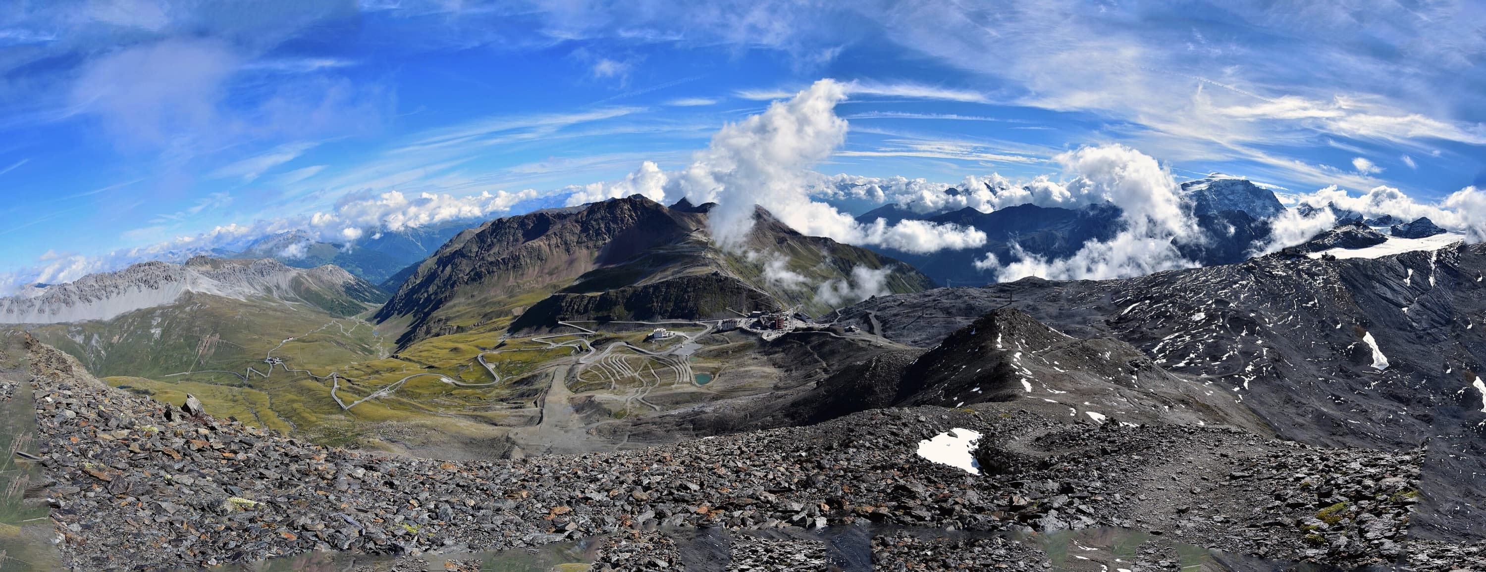
Valtellina and Alta Valtellina
Road cycling
Stelvio, Gavia, Mortirolo, Bernina, Foscagno: the Valtellina is a land of great climbs, and Tirano is the right place to start from.
Why here
The Valtellina, the valley of the great climbs
There are valleys you cross by car and valleys you climb by bicycle. The Valtellina belongs to the second kind: a long, bright furrow running from east to west, from which the roads branch off to some of the most celebrated passes in the Alps. Anyone who loves climbing finds here a rare collection of names that made cycling history: the Stelvio, the Gavia, the Mortirolo, and then the Foscagno, the Eira, the Forcola, the Bernina. Each has its own character: the Mortirolo is short and brutal, the Stelvio long and regular, the Gavia narrow and wild, the Bernina a long ascent through Switzerland.
The climbs are not just sporting routes: they are roads with a history. The Stelvio road was built between 1820 and 1825; in 1953 the Giro d'Italia tackled it for the first time, with Fausto Coppi dropping Hugo Koblet, and since then it has been tied to the name of the Cima Coppi, the highest point of the Giro. On the Mortirolo, on 5 June 1994, Marco Pantani attacked and won solo in Aprica; on the Gavia, in 1988, the Giro crossed a snowstorm that everyone still remembers. Riding these roads today, perhaps with a sign or a monument beside you, is also a way of entering the story of cycling.
Tirano has an almost perfect position, as you see by looking at the map: it lies at the eastern end of the valley, at the foot of the Bernina road and a few kilometres from the Mortirolo and from Aprica. From the town you set off directly by bike for the Aprica Pass and the Bernina Pass; for the Mortirolo it is about ten minutes by car to Mazzo di Valtellina; Bormio and the Stelvio are about forty minutes away, Santa Caterina and the Gavia a little under an hour. Those travelling without a car find the railway station and the Red Train in Tirano, and can organise different days without moving their suitcase.
Then there is comfort, which on holiday counts as much as the climbing. Tirano is a town on a visitor's scale: hotels and B&Bs near the station, restaurants with traditional dishes, shops and a bike workshop. For a cyclist it means choosing each morning the right climb according to the weather and the legs, and returning each evening to the same bed after a dinner of pizzoccheri and a glass of Valtellina Superiore. An Alpine base, comfortable and easy to reach, for those who stay three days, for those who have a week, and also for those who come only for a long weekend and want to make the most of it.
- 21.6 km
- from Bormio to the Stelvio Pass, at 2,758 metres
- 1,913 m
- of ascent from Tirano to the Bernina Pass
- 2,315 m
- at the Forcola di Livigno, from Tirano through the Valposchiavo
- 10 min
- from Tirano to Mazzo di Valtellina, for the Mortirolo, by car
Where to ride
An overview of the places, and how easy they are to reach
From the climb that starts at your doorstep to those that require a transfer: here are the great areas for road cycling. Driving times are calculated from Tirano to the nearest drivable point: always check route, distances and closures before setting out.
Tirano and the Media Valtellina
It is the most convenient starting point, because two great climbs start from the town: the Aprica Pass, about 22 minutes by car if you prefer to start from up there, and the Bernina Pass, which you ride from Tirano into Switzerland. Mazzo di Valtellina, where the Mortirolo starts, is about ten minutes by car. For rest days there is the Sentiero Valtellina, the valley-floor cycleway, flat and perfect for loosening the legs.
Bormio and the Stelvio
About 38 minutes from Tirano begins the most famous climb: from Bormio, at 1,225 metres, you climb to the Stelvio Pass, at 2,758. It is a long, regular ascent that asks for constancy. Bormio is also the centre of projects dedicated to cyclists: Stelvio Epic Rides is a non-competitive challenge of ten climbs to complete at your own pace, without rankings, while Enjoy Stelvio Valtellina closes some of the great passes to motor traffic on set days.
Santa Caterina Valfurva and the Gavia
A little under an hour from Tirano, Santa Caterina is the gateway to the Gavia Pass, at 2,621 metres. From here the climb is about thirteen kilometres, with an average gradient that sources give at around 6.5%: shorter than the Stelvio, but on a narrow, wild road that demands attention, especially on the descent. It is the pass the Giro d'Italia loved and feared in 1988.
Livigno and the Foscagno
From Bormio the Foscagno Pass, at 2,291 metres, is the only road to Livigno without leaving Italy: a long, gradual climb that continues, after a descent, over the nearby Eira Pass. Livigno is a duty-free zone. For a full ride, the Bormio tourist site gives a loop of about 127 kilometres and 2,800 metres of ascent that passes through the Forcola, Switzerland and Tirano.
Switzerland, a step away
From Tirano the border is a few kilometres away: the Bernina road runs through Campocologno, Brusio and Poschiavo before climbing to the pass, at about 2,330 metres. The Forcola di Livigno, at 2,315 metres, links the Valposchiavo with Livigno. With a valid ID in your pocket, these are days that offer landscapes very different from those of the valley.
Other, quieter climbs
Those who want less traffic can consider Cancano, in the territory of Valdidentro, and the Passo San Marco; the road to Campo Moro, in the Valmalenco, is reported closed because of a landslide: always check the state of the roads before choosing a ride. The Mortirolo has other sides, less hard than the Mazzo one: from Grosio, for example, it is about 14.8 kilometres long.
When to go? The roads at altitude are cleared of snow late in the season and usually stay open from June to October: in 2026 the Gavia, from the Valtellina side, opened on 27 May. The Foscagno and the Bernina are indicated by some sources as passes that stay open longer. The dates change every year and snow can linger: always check the state of the passes, and remember that even in summer it can be cold at the top.
The routes
Suggested routes
Each page shows the route map on Komoot, with the essential information in the header and the link to the route page, where you find photos and comments.
 Komoot · © OpenStreetMap
Tirano-Aprica-Trivigno
42.9 km2 h 50 min↗ 1325 mDemanding
From Tirano to Trivigno, the alp of Tirano at about 1,800 metres, via Aprica and the Pian di Gembro Nature Reserve: 43 kilometres, with the option of carrying on towards the Mortirolo.
Discover the route →
 Komoot · © OpenStreetMap
Tirano-Grosio loop
34 km1 h 35 min↗ 348 mModerate
A 34-kilometre loop from Tirano to Grosio, along the Sentiero Valtellina and through the historic villages of the valley: perfect also as a workout.
Discover the route →
 Komoot · © OpenStreetMap
Sentiero Valtellina from Tirano to Sondrio
61.4 km2 h 47 min↗ 473 mModerate
A relaxed 61-kilometre ride, with no significant climbs, along the Sentiero Valtellina from Tirano to Sondrio: for families, but also as a workout.
Discover the route →
 Komoot · © OpenStreetMap
Tirano-Gavia Pass
131.5 km7 h 14 min↗ 2405 mDemanding
From Tirano to another legendary climb, the Gavia Pass: 131 kilometres, over 2,400 metres of ascent, with a gentle start through the Alta Valle and Bormio.
Discover the route →
 Komoot · © OpenStreetMap
Tirano-Carona: the Orobie side
43.2 km2 h 24 min↗ 893 mModerate
A beautiful and little-known 43-kilometre route through the woods of the Orobie side from Stazzona to Carona, returning on the Sentiero Valtellina.
Discover the route →
 Komoot · © OpenStreetMap
Tirano-Grosio-Bormio loop
83 km3 h 54 min↗ 982 mDemanding
An 83-kilometre loop from Tirano, through Grosio and Bormio: about 980 metres of ascent, almost all on asphalt and mostly on a cycle path.
Discover the route →
 Komoot · © OpenStreetMap
Tirano-Stelvio Pass
123.1 km6 h 57 min↗ 2521 mDemanding
From Tirano to the legendary Stelvio Pass: 123 kilometres and over 2,500 metres of ascent, with the gentle climb along the Sentiero Valtellina as far as Bormio.
Discover the route →
 Komoot · © OpenStreetMap
Tirano-Mortirolo Pass from Tiolo
49.1 km3 h 15 min↗ 1468 mDemanding
From Tirano to the Mortirolo Pass climbing from Tiolo, above Grosio, and descending to Mazzo di Valtellina: 49 kilometres and about 1,470 metres of ascent.
Discover the route →
 Komoot · © OpenStreetMap
Tirano-Torri di Fraele and Cancano Lakes
115 km6 h 17 min↗ 1889 mDemanding
A full day in the saddle: 115 kilometres from Tirano to the Torri di Fraele and the Cancano Lakes, returning via Isolaccia, Bormio and Grosio.
Discover the route →
 Komoot · © OpenStreetMap
Tirano-Teglio-Chiuro loop
54.2 km2 h 51 min↗ 924 mDemanding
A 54-kilometre loop from Tirano, through Teglio and Chiuro: about 920 metres of ascent, almost all on asphalt, with a stretch on a cycle path.
Discover the route →
 Komoot · © OpenStreetMap
Tirano-Mortirolo Pass from Mazzo di Valtellina
46.3 km3 h 03 min↗ 1448 mDemanding
From Tirano to the Mortirolo Pass climbing from Mazzo di Valtellina, the toughest side, and descending towards Tiolo: 46 kilometres and about 1,450 metres of ascent.
Discover the route →
 Komoot · © OpenStreetMap
Tirano-Aprica-Mortirolo loop
66.2 km4 h 19 min↗ 1868 mDemanding
A 66-kilometre loop from Tirano, through Aprica, the Trivigno Pass and the Mortirolo: about 1,870 metres of ascent, for the fit.
Discover the route →
 Komoot · © OpenStreetMap
Tirano-Sondrio: the Wine Road and the Sentiero Valtellina
63.5 km3 h 22 min↗ 924 mDemanding
One of the most beautiful cycling routes in the Valtellina: 63 kilometres between Tirano and Sondrio, out on the wine road and back on the Sentiero Valtellina.
Discover the route →
Rental and repairs
Renting a road bike in the Valtellina
You do not need to bring your bike from home: in the places where the climbs are concentrated there are shops that rent road bikes, e-road bikes and gravel bikes, and have a workshop. In Bormio, Bormio Rental, in via Battaglion Morbegno, rents road and gravel bikes, also electric, and has a mechanical service; Stelvio Experience, in via Stelvio, offers rental and guided tours on the most famous routes. In Livigno the Mottolino Rent & Bike Hub also rents road bikes. In Valdidentro there is Mapo Bike, with rental of road bikes, mountain bikes and e-bikes and a repair workshop.
In Tirano, in the old town, there is Cicliama, in via Trivigno: a shop with sales, rental and a workshop to repair your bike, useful if a gear breaks or a tyre goes flat far from home. Road bikes also appear in its catalogue: ask directly which ones are available for rent. The Valtellina Rent a Bike point at the Tourist Office, on the other hand, focuses on city bikes, mountain bikes and e-bikes.
A few practical tips, so as not to end up with the wrong bike on the wrong day. Book ahead in high season, especially at summer weekends and in August; choose the size carefully and have the saddle and handlebar adjusted; for the long climbs ask for easy gearing, with a compact chainset and a large sprocket, and check pedals, brakes and tyres before setting out. Prices and seasons change every year: check the shops' websites.
Where to rent and repair
A list of places, from Tirano towards the upper valley. Services, hours and seasons must be confirmed with the managers.
Tirano and around
Cicliama ↗
Tirano · Via Trivigno 2
- Road bikes
- Rental
- Repairs
- Sales
A shop in the old town: sales, rental and a workshop for repairs; the range includes mountain bikes, road bikes, gravel and e-bikes. The website does not list the rental models: ask for what you need.
Bormio and Valdidentro
Bormio Rental – Rossignol Pro Shop ↗
Bormio · Stazione a valle della cabinovia (Via Battaglion Morbegno 25)
- Road bikes
- Rental
- E-bike
- Repairs
- Sales
The bike park shop: e-bikes, mountain and downhill bikes, road and gravel bikes, mechanical service and second-hand bikes. Season given as 16 May to 11 October 2026, every day from 8.30 to 18.30.
Stelvio Experience ↗
Bormio · Via Stelvio 5
- Road bikes
- Rental
- Guided tours
Bike rental and guided tours on the most famous Alpine routes; hours given as every day from 8.00 to 19.30. The website does not list the models: ask about road bikes and e-road bikes.
Celso Sport ↗
Bormio · Via Battaglion Morbegno 1
- Road bikes
- Rental
- Sales
Bike rental and sales in Bormio. According to the Bormio tourist listing it also rents road bikes and e-road bikes: confirm availability with the shop.
Mapo Bike ↗
Valdidentro · Via Nazionale 91
- Road bikes
- Rental
- E-bike
- Repairs
Rental of road bikes, mountain bikes and e-bikes, with a workshop for every kind of repair. Phone and email come from a single tourist listing: reconfirm them before setting out.
Livigno
Mottolino Rent & Bike Hub ↗
Livigno · Via Bondi 473/A
- Road bikes
- Rental
- E-bike
- Repairs
- Sales
Livigno's rental hub: downhill, enduro, gravel, road bikes, e-bikes, city bikes and kids' bikes, with a workshop for repairs. According to a specialist source it is also a Trek dealer. Contact details to be reconfirmed on the website.
Information gathered from public sources: hours, prices, seasons and model availability change. Before setting out contact the shop and book, especially in high season.
The rules
How to ride a road bike wisely
The roads of the great passes belong to everyone: to those who ride, to those who drive, to those who live at altitude. A few rules of common sense make the difference between a good day and a problem for someone.
- 1
Respect the Highway Code
On roads open to traffic the rules apply to everyone: keep to the right, respect priorities and signs, and watch the hairpins, where cars and motorbikes appear suddenly.
- 2
Lights and visibility
Outside built-up areas, from half an hour after sunset to half an hour before sunrise, and in all tunnels, the regulations require a reflective vest or braces, and the bicycle must have lights. Better to always have lights on, even by day, and a powerful light for the tunnels.
- 3
The helmet
According to the sources consulted there is no general helmet obligation for adults in Italy, but rules can change: check the ones in force. On mountain climbs and descents always wear it, obligation or not.
- 4
Ride safely in a group
When there is traffic, especially on descents and in hairpins, ride in single file and leave space. Avoid taking the opposite lane and do not cut the bends: oncoming traffic cannot be seen.
- 5
Check your brakes, and use them well
The descents of the great passes are long: rims get hot. Brake gradually before bends, alternate front and rear brakes and do not wait until the last moment. Check the pads before setting out.
- 6
Weather and altitude
The weather changes fast: above two thousand metres it can be cold, rain or snow even in summer. Bring a windproof, gloves, a gilet and a light thermal blanket for the descent, and judge the start according to the forecast.
- 7
Plan the ride
Check weather, ascent and duration, and choose a climb suited to your fitness. Tell someone where you are going. Carry water, food, a spare inner tube and a charged phone, and remember that in an emergency the single number is 112.
- 8
The Swiss border
For the Bernina and the Forcola di Livigno you cross the border with Switzerland: carry a valid ID and check the rules in force, including on bike equipment and on the currency.
- 9
Closures and traffic-free days
Some passes close for snow, landslides or works, and on some summer days the great passes are reserved for cyclists, with the road closed to motor traffic. Before setting out always check the up-to-date information.
- 10
Respect those who live up there
The roads cross alpine pastures, villages and reserves: slow down near herds and built-up areas, do not leave litter and do not disturb the animals.
These are common-sense indications and do not replace the rules in force or the indications of the managers of roads and parks.
The apps
Apps for maps and navigation
With a smartphone, or a bike computer, you follow the route and stay on the road even without a signal. Here are some apps that can be downloaded free, at least in the basic version: advanced features, in some cases, are paid.
Komoot ↗
Planning, voice navigation and a community with photos and comments. You can import a GPX and save maps offline; the free version has limits.
Strava ↗
Records your rides and shares them with friends; segment leaderboards let you compare on the climbs. Some features are paid.
Ride with GPS ↗
To plan and follow a road route, with GPX file import and navigation on the bike computer. Some features are paid.
Climbfinder ↗
A database of climbs with profiles, length and gradient, useful to compare roads before choosing one.
Garmin Connect ↗
For those who use a Garmin bike computer: you import the GPX file and load it onto the device.
OsmAnd ↗
Offline maps based on OpenStreetMap, with GPX track and navigation. The free version has a limit on the number of maps you can download.
Organic Maps ↗
Free offline maps, simple and ad-free, also with GPX tracks. Useful as a backup map.
Google Maps ↗
To reach the starting point: you can download the offline maps of an area and check travel times.
A tip that applies to all of them: download the maps before setting out, while you still have a connection. In the valley phones do not always get a signal, and the network drops as you climb. If you ride with a bike computer (Garmin, Wahoo and the like), you can sync the route from Komoot.
See the climbs on the map
On the main map you find, with the road bike icon, the passes and places along the climbs: switch on the filter and choose your ride.
Road conditions, closures and service seasons change. Always check official sites and on the spot before setting out.