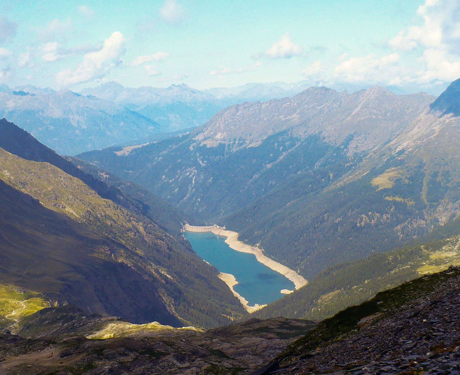
Photo: MatthewGhera · CC BY 3.0

Very easy to reach
The valley “of fine appearance”: the longest of the Orobic valleys, with a great alpine lake, old iron mines, passes leading to Val di Scalve and woods where silence is the rule.
- Type
- Valley
- Municipality
- Aprica
- From Tirano
- Visit time
- Opening
- June 15 - September 30An outdoor place, always reachable. At altitude snow can make roads and paths impassable: they generally clear from June-July to September. An estimate based on the altitude.Indicative dates, not official: check before you go.
- Activities
- HikingTrekkingMountain biking
Two and a half kilometres below the Aprica Pass, heading towards Tresenda, a turn-off slips into the mountain and vanishes among the firs. This is the entrance to Val Belviso, the longest and widest of the Orobic valleys, fifteen and a half kilometres of woods, pastures and water. The name, in a popular reading, recalls its “fine appearance”, and you only need to walk a stretch to see why.
The valley is crossed by a line of interest to geologists too: the Insubric Line, a fault more than a thousand kilometres long which, in a scientific image, marks the meeting of the African and Eurasian plates. A curiosity told with a smile: by this image Teglio would lie on the “Asian” side and Val Belviso right on the border between the two worlds.
The valley has a history of work. For centuries iron was extracted and worked here: until the early 19th century, in the Val Demignone, the remains of furnaces survive at heights between 1,910 and 2,030 metres, and the ore passed over the Orobic passes to Val di Scalve. Two historic hamlets, Ganda and Verigna, with the church of San Paolo, tell of daily life. And an old mule track, that of the Passo Venano, is part of the Cadorna Line of the Great War. Wildlife too has a memory: the last two bears of Val Belviso were shot on 8 November 1894. Today red deer, chamois, mouflon and roe deer live in peace under monitoring.
At the heart of the valley lies its jewel: Lake Belviso, at 1,485 metres, the largest lake in the Orobie Alps, about six kilometres long. It is an artificial reservoir created by the Frera dam, built between 1956 and 1959, which holds about 50 million cubic metres of water and is now managed by Edison. But the water is so clear and the shores so quiet that it seems always to have been there.
Getting there is easy. From Tresenda follow the road towards Aprica, then descend to the Ganda bridge, at 915 metres, at the mouth of the valley; from here a narrow road, passable by an ordinary car, climbs through San Paolo, at 1,216 metres, and the Rifugio Cristina, at 1,255, up to the Ponte Frera car park, at 1,373. Before setting out it is wise to check the state of the road. Beyond the hut there is a picnic area, and you can lunch at the hut or on the shore. From here starts the “gnome trail”, marked by wooden figurines, which leads to the dam and is suitable for trekking pushchairs and bicycles: a perfect walk for families, with a lakeside path to stop and breathe.
For those who want to walk further, the valley offers routes for every pair of legs. The path to the Belviso Pass climbs from about 1,500 metres to 2,518 in about three and a half hours. Higher up, the Torena Lakes and other alpine tarns, such as Lake Lavazza, Lake della Cima and Lake di Pisa, and Monte Torena, which nears 3,000 metres. From the lake a track skirts the shore and continues for about six kilometres, then trail 312 climbs into Val di Pila, crosses the difficult Scale di Pila and reaches Malga di Pila, at 2,010 metres, from where you reach the Rifugio Nani Tagliaferri, at 2,328 metres, on the Val di Scalve side. Inaugurated on 22 September 1985 and named after a mountaineer who died in Peru in 1981, the hut has 60 beds. The full circuit, touching the Passo Venano, the Passo Demignone and the Passo Venerocolo, is an undertaking for expert hikers, about eight hours and 1,580 metres of ascent.
Mountain biking too has its high-altitude route here: a long loop on military roads and rideable paths, with exceptional views, which from Aprica touches Malga Magnolta, the Passo Venerocolo, the Belviso dam, Ponte Frera and the Rifugio Cristina.
Then there are the quiet, the woods of fir, alder, birch and rhododendron, the view of Monte Gleno and air that is breathed more slowly. Val Belviso is part of the Orobie Valtellinesi Park and has an atmosphere different from that of nearby Aprica, livelier and busier: a threshold of a few kilometres, to cross when you long for silence.
From Tirano: distance, driving time and day trip
Val Belviso from Tirano: about 30 minutes by car (19 km). You drive down the SS38 to Tresenda, follow the road towards Aprica and enter the Val Belviso, a quiet, little-trodden Orobie valley. A comfortable trip: the round trip is easily done in a day, with plenty of time to visit and be back in Tirano for dinner. Tirano is the ideal base to visit the Valtellina: hotels and B&Bs, restaurants, shops, supermarkets, the Bernina Red Train station and buses to get around.
Refreshment stops
Before you set out, always check that the hut is actually open on its official website.
Mountain hut & refreshments
Rifugio Cristina
Photo: Orobicon (Wikipedia italiana) · CC BY-SA 3.0, Gianluca Cogoli · CC BY 3.0